This lab introduces students to creating geospatial web services through ArcGIS Online and ArcGIS Server in which they will author and publish feature classes, raster, and an Excel CSV file via ArcMap and ArcGIS Pro.
In this lab students will engage in the following tasks:
- Publishing feature hosted services through ArcGIS Online
- Publishing a tiled map service using ArcGIS Server
- Author a map document, create a feature service, and add this to a web map
Methods
Part 1: Publishing feature hosted services through ArcGIS Online
Section 1: Publishing a feature hosted service using a shapefile
> Open ArcMap and load the data for Part 1 Section 1 which contains Wisconsin features including cities, interstates, highways, and counties; close ArcMap
> Return to the Part 1 Section 1 folder, select all the features, and right click and select 'Send to' > 'Compressed (Zipped) folder' (Figure 1); this will create a zip file of the selected data in the folder
 |
| Figure 1: Creating a zip file |
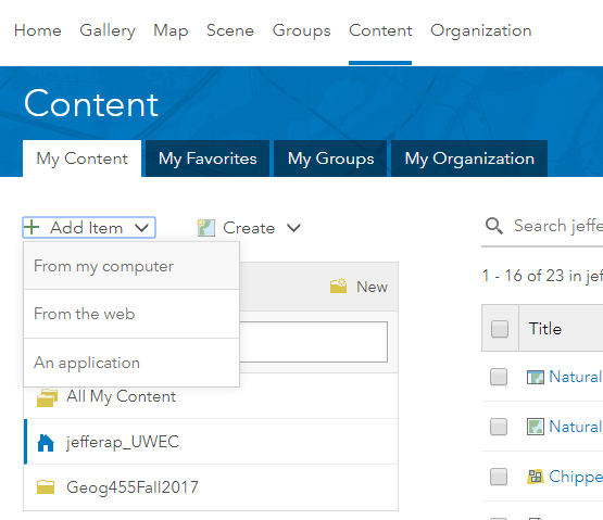
> Sign in to ArcGIS Online for organizations; click on 'Content' > 'My Content' > 'Add Item' > 'From My Computer' (Figure 2); click 'Choose File' button and select the 'Wisconsin_transportation.zip' file created earlier
 |
| Figure 2: Add Item from computer in ArcGIS Online |
| Figure 3: Wisconsin transportation data service feature layer thumbnail |
Section 2: Publishing a feature hosted service using a CSV file
Instead of using a shapefile, we will now publish an Excel CSV (comma separated value) file. The file is titled 'WI_fire_occ_2004' and is located in the Lab 2 Data folder. The Excel sheet must be saved as a CSV file before it can be published.
> Open the 'WI_fire_occ_2004' file; save it as a CSV file and name it 'WI_fire_occ_2004_YourLastName'
> In ArcGIS.com, follow the similar procedure as in the previous section to publish the file; use the recently saved fire occurence CSV file as the input file; name it something along the lines of 'Wisconsin 2004 fire occurrence'; add at least two appropriate tags
> Under 'Locate features by:' select 'Coordinates'; under the 'Location Fields' heading for the 'POINT_Y' Field Name select 'Latitude' and for the 'POINT_X' Field Name select 'Longitude' (Figure 4)
 |
| Figure 4: Setting up the coordinates values from the CSV file in the 'Add an item' window |
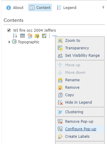
> When clicking on any fire occurrence, we only want the FIREDATE field to show; click on 'Content' > 'More Option' > 'Configure Pop-up' (Figure 5) to configure the pop-ups
 |
| Figure 5: Configure pop-ups in map viewer |
Section 3: Publishing a feature hosted service using an ArcMap document
Part 2: Publishing a tiled map service using ArcGIS Server
Section 1: Publishing a service to ArcGIS Server using ArcMap
Section 2: Consuming the map service in a web application
Section 3: Publishing a service to a Portal using ArcGIS Pro
Part 3: Author a map document, create a feature service, and add these to a web map
Section 1: Author a feature access and time-enabled service data
Section 2: Consume a feature access time-enabled service
Results
Result #1: Feature hosted service using a shapefile
URL: http://uwec.maps.arcgis.com/home/item.html?id=12cb4fa746504ba588d833e8f9d3c469
The end product 'Wisconsin transportation date service_Jeffers' feature hosted using a shapefile can be seen below (Figure ):
| Figure : Wisconsin transportation data feature hosted service that was created using a shapefile |
Result #2: Feature hosted service using a CSV file
URL: http://uwec.maps.arcgis.com/home/webmap/viewer.html?useExisting=1&layers=8ca5b88b0c3e4da4a9fae37b7ecea16f
The end product of the 'WI_fire_occ_2004_Jeffers' feature hosted service using a CSV file can be seen below (Figure ):
 |
| Figure : Wisconsin 2004 fire occurrence feature hosted service that was created using a CSV file |
Result #3: Feature hosted service using an ArcMap document
URL: http://uwec.maps.arcgis.com/home/webmap/viewer.html?useExisting=1&layers=c63294be4f7c42bbaecf3a61a1001a51
The end product of the 'Wisconsin_WaterBodies_Service_Jeffers' feature hosted service using an ArcMap document can be seen below (Figure ):
 |
| Figure : Wisconsin water bodies feature hosted service that was created using an ArcMap document |
Result #4: Published ArcGIS Server service using ArcMap
URL: http://www.arcgis.com/home/webmap/viewer.html?url=http%3A%2F%2Fgeog01.uwec.edu%2Fserver%2Frest%2Fservices%2Fjefferap%2FJeffers_Chippewa_Valley_urban_Landuse%2FMapServer&source=sd
The end product of the 'Jeffers_Chippewa_Valley_urban_Landuse' MapServer service that was published using ArcMap can be seen below (Figure ):
 |
| Figure : Chippewa Valley urban land use ArcGIS Server service that was created using ArcMap |
Result #5: Published ArcGIS Online service using ArcGIS Pro
URL: http://uwec.maps.arcgis.com/home/webmap/viewer.html?useExisting=1&layers=0fdabfa9f40c467d8076b496b2f3cefa
The end product of the 'Chippewa_valley_corridor_Jeffers' tile layer that was published using ArcGIS Pro can be seen below (Figure ):
 |
| Figure : Chippewa Valley urban land use ArcGIS Online tile layer that was created using ArcGIS Pro |
Result #6: Feature access and time-enabled service data
URL: http://www.arcgis.com/home/webmap/viewer.html?url=http%3A%2F%2Fgeog01.uwec.edu%2Fserver%2Frest%2Fservices%2Fjefferap%2FNatural_Disasters_AJ%2FMapServer&source=sd
The end product of the 'Natural_Disasters_AJ' MapServer service that was published using ArcMap can be seen below (Figure ):
 |
| Figure : U.S. natural disasters (earthquakes and hurricanes) ArcGIS Server service that was created using ArcMap |
Sources
Mastering ArcGIS:
Price, Maribeth Hughett. Mastering ArcGIS. New York: McGraw-Hill Education, 2016.
Wisconsin DNR:
Cyril Wilson:
USGS:
NOAA:
No comments:
Post a Comment